Course |
Excavation |
Accommodations |
Dates & Fees |
Team |
Free Time |
Seminars |
Official web |
|
Course
This course is aimed at students and people interested in archaeology who wish to participate with us in this archaeological course at Los Cantos, located 2km south of Bullas in Murcia (Spain) where they will be able to study first hand the model of rural settlement in Roman times known as Villae.
This settlement consists of a large building with many rooms dedicated to various functions, among which we distinguish a residential area with bedrooms most of which have beautiful geometric mosaics and a thermal resort, as well as an industrial and working area dedicated to economic activities. As far as the chronology is concerned, we have an occupation beginning in the middle of the first century AD until AD II. And a second phase that extends from the 3rd to 4th century AD.
In recent years the CEPOAT has been working on this site’s development of their excavations, as the director of CEPOAT is now the director of the excavation of the site.
The Archaeology course we offer is a comprehensive training course in fundamental aspects such as stratigraphy, GIS, photogrammetry, CAD, topography, field drawing, inventory of materials, etc.
The program developed is as follows:
1. Introduction to archaeology.
1. Concept, limits and meaning of archaeology.
2. Archaeology and sources: written and materials.
3. Methods and techniques: the exploration, excavation and dating methods.

2. Methods and techniques of archaeological excavation.
1. The formation of the archaeological record: General deposition processes.
2. The concept of strata and training: relative dating. Terms ante quem and post quem. The concept of strati-graphic unit. Strati-graphic relationships between units. The matrix Harris.
3.The system open area excavation and its application in different situations.
4.The data record. The daily and strati-graphic records. The field drawing and photography in the excavation.
5.La manual collection of objects. Artifacts and registration. The recovery of small remains: screening and flotation. The first preservation of the remains in the field.

3. The archaeological field drawing.
1. Introduction to archaeological field drawing: registration.
2. Main instruments and materials of archaeological field drawing.
3. Techniques for making the flatness of the site: the perpendicular to the reference axis, triangulation, cross drawing, elevations and walls.
4. The flatness: scale and landmarks.
5. The use of new technologies for the drawing: photogrammetry.
6. The Kite aerial photography (KAP).

4. The layout of the site: basic principles of surveying, leveling and total station.
1. The layout of the site: basic principles.
2. Basic Principles of surveying and leveling.
3. How to install a level and take dimensions.
4. The use of the Total Station.

 5. The recording of archaeological remains: materials inventory.
1.The archaeological inventory: method and phases.
2.Physical characteristics and technology of archaeological materials.
3.Physics description , use and functionality of the archaeological material.
4.The record of archaeological materials: inventory. Cleaning, sorting, and numbering. Tables and databases.

6. Ceramics: Roman pottery.
1. Republican Roman pottery
2. Imperial Roman pottery
3. Late Roman pottery: main productions.
7. The technical drawing of archaeological materials.
1. The technical drawing of archaeological materials: basic principles.
2. Materials needed for technical drawing of archaeological materials.
3. Phases technical drawing: outline, details, profile and section.
4. Scale, frame and shadow drawing artifacts.
5. The technical drawing of pottery pieces.
6. The digital drawing of archaeological materials.


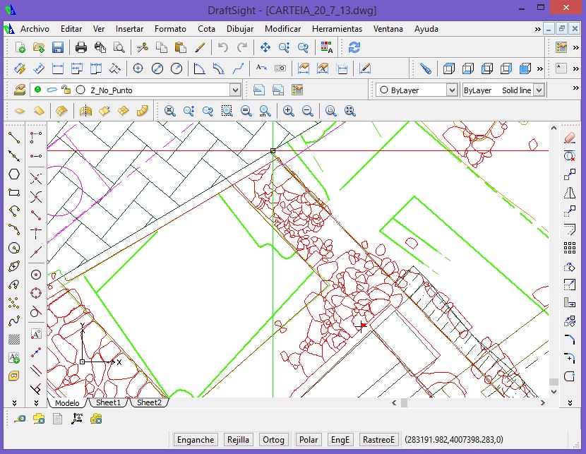
8. Computer Management archaeological record: Draftsight, Inkscape, Gimp, Databases, etc.
1. Vector Drawing with Draftsight and Inkscape.
2. Photo retouching with Gimp.
3. Databases with Libre Office.

9. SIG. Applications to the archaeology of the area.
1. Basic concepts of cartography.
2. Using QGIS.
3. Geo-referencing of raster data.
4. Generation of Digital Terrain Models.
5. The interpolation of vector data.

10. Preventive conservation and restoration of sites.
1. Buried and exhumed objects. The conservation of movable and immovable property.
2.Getting care of the objects found in the intervention. The figure of the restored-conservative archaeological excavation equipment.
3. Preventive conservation of archaeological remains: bindings and coating remains.
4. The restoration of the deposits: intervention criteria. Methods and techniques.

11. Presentation of results: writing memoirs, interpretation and publications.
1. The development of the report of archaeological excavation.
2. The presentation of the results: Final Report.
3. Content of Memory: results, performance, floor plans, records of strati-graphic units, photographic repertoire, materials inventory, etc.
4. Publication of the results: social obligation
5. How to prepare press releases, scientific articles and conferences.

The daily agenda is as follows:
Daily field activities:
The course is divided into different activities throughout the day.
On the first day will be given an explanation of the site, structures and phases, and the intervention project for students to be aware at all times of what to do and plan prior to an excavation.
The working system will also be divided between in morning and afternoon, in order that students will go through each and every phase of archaeological excavation and be able to acquire the basic knowledge and methodology necessary to undertake archaeological intervention.
Morning (8:00 to 13:30):
Student will be using field theory and practice of the course topics 1, 2, 3 and 4.
Each morning students will be divided into 5 groups of 5 persons who will be assigned tasks through rotations in their archaeological area of group coordination, decision levels, completion of daily field drawing, taking photographs and conducting sheets Strati-graphic units.
Afternoon (17:00 to 20:00):
All students will be taught theory and laboratory practice items 5, 6, 7, 8, 9, 10 and 11.
In the afternoon the students will remain in their groups, they then will carry out archaeological laboratory work for a complete understanding of archaeology in all its facets and phases, either conducting inventory of materials found in the excavation during the morning, drawing the most significant items found, or the computerization of data collected in the field, through databases for the daily registration of materials, units and photographic registration, while vectorization of field drawings using CAD programs for integration into general planimetry. Moreover we will make emphasis on the importance of conservation and restoration of archaeological remains through restoration work in the laboratory, while also delve into how it should be presented in an archaeological memory.
Timeline:
| Morning from 8 to 14h | Monday | Tuesday | Wednesday | Thursday | Friday | Saturday |
| 8,30 a 9,30: Level | A | B | C | D | E | optional review |
| 9,30 a 10,30: Photogrammetry | B | C | D | E | A | optional review |
| 10,30 a 11 Mid Morning snack | – | – | – | – | – | |
| 11 a 12,30: Field Drawing | C | D | E | A | B | optional review |
| 12,30 a 2: Total Station | D | E | A | B | C | optional review |
| 8 a 2: Diary, Photos, Level & EU | E | A | B | C | D | optional review |
| Afternoon from 17 to 20h | ||||||
| Inventory | A | B | C | D | E | optional review |
| Photogrammetry & SIG | B | C | D | E | A | optional review |
| Ceramic drawing | C | D | E | A | B | optional review |
| Ceramic wash | D | E | A | B | C | optional review |
| Diary & EU Register on PC | E | A | B | C | D | optional review |
| Task | Morning | Task | Afternoon | ||
| 1 | Diary & EU, : Explanation and filling of field diary and tabs of Stratigraphic Units, as well as taking daily topographic measurements. | 1 | Ceramic wash: Ceramic washing process and initial classification. | ||
| 2 | Photogrammetry: Explanation of the operation and use of the photogrammetry by means of an example in field to be done by the students. | 2 | Inventory: Explanation of ceramic classification systems and inventory through databases. | ||
| 3 | Level: Explanation of use and handling of Level for the taking of topographic measurements. | 3 | Ceramic drawing & vectorization: Explanation of the ceramic drawing by hand and its vectorization using Inkscape. | ||
| 4 | Field drawing: Explanation of the traditional field drawing in the field. | 4 | Daily data Computerization: Computerization of the data collected during the excavation process in the morning. | ||
| 5 | Total Station : Management and use of Total Station for the topography of the site. | 5 | Archaematic with Draftsight (CAD), SIG (QGIS), Photogrammetry: Management of computer applications for specific use in archaeology. | ||
|
|
|
|
|
||
| Team 1 | Team 2 | Team 3 | Team 4 | Team 5 | |
| A | A | A | A | A | |
| B | B | B | B | B | |
| C | C | C | C | C | |
| D | D | D | D | D | |
| E | E | E | E | E | |
The course is developed within the concept of an International Course, so the vehicular languages will be English and Spanish. We will have at all times archaeologists and bilingual coordinators , who will give explanations in English and Spanish, so that students will be able to enjoy the opportunity to learn and improve their Spanish on this bilingual course.
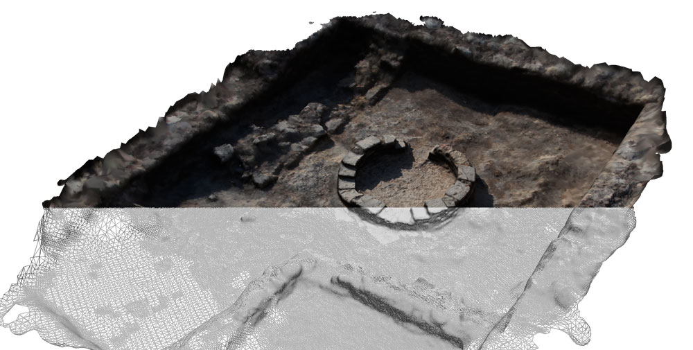
Excavation
The town of Los Cantos is known since March 1867 following excavations by Bernardino García, one of the first discoveries was a geometric type mosaic. Between 1905 and 1909 the excavations continued and they found a collection of sculptures among which stands out the well-known sculpture of the «Child of the Grapes», later emergency excavations were made in the years 1994-1995, after which the city bought the land on which the villa sits. Subsequently new campaigns have been developed in 2009 and in 2012.
With all the information of these interventions we can do a reconstruction of the built space. The villa is formed by an urban area which includes the dwelling as well as a building of thermal function, and it also has a space dedicated to economic activities. As far as the chronology is concerned, we have an occupation beginning in the middle of the first century AD until AD II. And a second phase that extends from the 3rd to 4th century AD.

At present we know that the structures conserved have an extension of more than 3,000 square meters, although the extension of the deposit is much greater.
Accommodations
Students in the course will reside on the Rural House in Bullas.
Capacity: 15 people.
Breakfast, mid morning snack, lunch and dinner will be prepared by a local chef at a nearby lodge restaurant. If there is a vegetarian student must advise us at the beginning of the course.
How to get Bullas:
Buses to Bullas can catch the bus station in Murcia daily every hour. http://mula.es/user/pdf/Murcia-Caravaca-Murcia.pdf
Location
Fees
European students: 300 €
European, not students: 500 €
Overseas, both students and not students: 800 €
Registration and Enrollment: You must pre-register by sending an e-mail to arqueologia@cdlmurcia.org and send your CV
For the completion of the course must make the payment of tuition by bank transfer to the College of Letters and Sciences of Murcia in Caixabank account ES5521008309261300018407 or Sabadell ES7800811016110001835987 indicating the name of the course and student name.
A copy of the deposit should be sent to arqueologia@cdlmurcia.org indicating the name of the course and the name of the student in the subject line.
Fees include: accommodation and meals – Seminars – Health insurance.
Students should arrive the day before from 7:00 p.m. onwards at the hostel.
Fees do not include airfare or arrival transportation.
Cancellation and Refund Policy: Once you have registered and paid for the course unfortunately there is no possibility of a refund.
Right of admission: The College and the course management reserves the right to refuse the selection of a candidate if the minimum health requirements are not met for each of the tasks that will be required during the course.
Once in the field, the program director reserves the right to expel a participant from the program due to his/her behavior in a group, in violation of Spanish laws, regulations or customs.
Team
Mr. Salvador Martínez Sánchez
 Director Bullas Wine Museum (Bullas Town Hall). Degree in Geography and History, History of Ancient History and Archeology. Scientific direction Villa Romana de Los Cantos (Bullas). Coordination / documentation of museum projects of Bullas Wine Museum, D. Pepe Marsilla House-Museum and Bullas Archeology Classroom. Tourist Development Agent (for the Aylas de Bullas) and address archaeological interventions in several municipalities of the Region (Cehegín, Cieza, Murcia, Caravaca de la Cruz, Bullas).
Mr. Alfredo Porrúa Martínez
 Degree in History by the University of Murcia. PhD courses: Urban life and urbanism in the Mediterranean area. It is dedicated to the study of Roman rural population and its relation in the transformation of the natural environment. He has published several articles on the Roman Villa of Los Cantos and works as a professional archaeologist.
Mr. José Javier Martínez García
Graduate in Ancient History and Archaeology in the University of Murcia. Graduate in Anthropology in Catholic University of Murcia. Doctoral Course: Urban Life and urbanism in the Mediterranean area, Master in Science in GIS, Master in Applied Archaeology, Master Teacher Education and Master in Egyptology. He has participated as Technical Director in several excavations of urgency and is currently involved in various international projects like Oxyrhynchus (Egypt) or Heracleópolis Magna (Egypt), Julia Valentia (Morocco) Modular Project and national project as Carteia, Baelo Claudia, Coimbra del Barrancho Ancho, Roman Bath of Fortuna, Villaricos, Begastri and Mazarrón Phoenician.
CEPOAT tab – Academia.edu – Facebook
Free Time
Sunday is a day off, so all students can do any activity that interests them such as visiting places in the neighborhood at their own cost or simply rest by the pool.
– The castle of La Puebla in Mula.
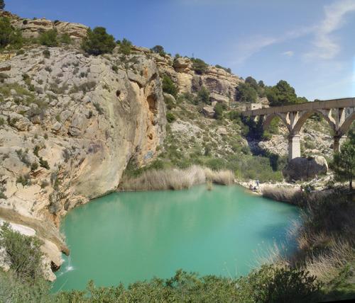
– Fuente Caputa.

Seminars
Throughout the campaign the archaeologists will prepare training seminars in archeology, methodology, GIS, photogrammetry, pottery drawing, materials inventory, etc in rotating groups for classes with groups of up to 5 people.
While all the information will be arranged for students in our Virtual Classroom before, during and after training.
Seminars and workshops:
– Introduction to Total Station

– Introduction to drawing in Field

– Introduction to Kite Aerial Photography – KAP

– Introduction to Stratigraphy with Harris Matrix methodology.

– Introduction to drawing materials

– Introduction to inventory in Data Base software.

– Introduction to GIS with software QGIS.

– Introduction to CAD with software Draftsight
– Introduction to Photogrammetry with software Python Photogrammetry Toolbox and meshlab